

If you want an ordinary swim before work—not a surf session—the Bali beach nearest your home may be the wrong choice. Sanur’s sheltered lagoons, calmer stretches around Nusa Dua and conditional swimming opportunities at Jimbaran deserve a different assessment from Kuta, Berawa or Batu Belig.
No Bali beach is guaranteed safe year-round. Choose a promising location, then check the forecast, tide, flags and actual conditions on every visit.
Where can you swim in Bali regularly?
Sanur, Nusa Dua and Jimbaran are conditional starting points
For regular recreational swimming, start by investigating Sanur’s lagoon areas, Nusa Dua’s nearshore beaches and Jimbaran Bay. Official tourism guidance describes shelter or relatively calm water in these locations, but that is a description of their general character—not permission to enter on any particular day.
The useful question is not simply “Is this a swimming beach?” It is “Is this particular stretch suitable for swimming now, and is someone qualified checking it?”
| Location | Why swimmers consider it | Main limitation | What to verify |
|---|---|---|---|
| Sanur | Offshore reefs shelter shallow lagoons | Low tide can leave inadequate swimming depth | Usable depth, reef boundary and current conditions |
| Mengiat and Nusa Dua | Generally calmer coastal waters | Reefs and tidal shallows complicate the swimming area | Local swimming zone, depth and flags |
| Geger | Part of the Nusa Dua coastal area | Documented current hazards offshore | Nearshore advice rather than assumptions about the wider coast |
| Jimbaran and Kedonganan | Relatively calm water under suitable conditions | Conditions and supervision still require confirmation | Waves, currents and personnel actually on duty |
| Kuta and the west coast | Popular beach access and surfing | Surf exposure and documented strong-current locations | Whether a permitted, supervised swimming zone exists |
A swimming shortlist is not a safety ranking
Do not turn this comparison into a permanent league table. A sheltered beach with insufficient depth or a restriction is not a better swimming choice than a beach where conditions have been assessed and a permitted zone is operating.
For residents, the practical advantage is having alternatives: a beach walk, a different locally approved swimming stretch, or a pool when the sea is unsuitable.
Can you swim at Sanur Beach?
Sanur’s swimming lagoons are different from the surf beyond the reef
Indonesia’s tourism ministry distinguishes Sanur’s shallow, reef-protected lagoons from the surfing water beyond the offshore reef. That distinction matters: the calmer nearshore environment is the reason to consider Sanur for swimming, not an invitation to cross the reef or follow surfers outward.
Assess the exact place you intend to enter. A description of “Sanur Beach” covers a broader coastline than your actual swimming patch, and a calm-looking lagoon does not establish that every entrance or reef opening is suitable.
Ask local lifesaving personnel where swimming is appropriate that day. Keep your plan within the area they identify rather than treating the offshore reef as a destination.
Low tide can make Sanur too shallow for a useful swim
The tourism ministry also notes that Sanur’s reef areas can become very shallow at low tide. A sheltered lagoon may therefore be attractive for looking at the water while offering little usable depth for swimming.
Check both the tide information and what is actually in front of you. Do not solve a shallow-water problem by automatically walking farther toward the reef or entering a channel.
- Look for sufficient depth in the locally advised swimming area.
- Check the seabed and entry route rather than assuming uniform sand.
- Change your plan if obtaining swimming depth would require leaving the advised area.
If you are considering Sanur as a long-stay base, the Sanur neighbourhood and long-term rental guide covers the housing decision separately. Beach proximity still needs to be judged against your actual swimming routine.
Are Nusa Dua, Mengiat and Geger suitable for swimming?
Mengiat has reef shelter, but the seabed is not uniformly deep sand
Indonesia’s official beach guidance describes Nusa Dua’s coastal waters as relatively calm. This makes the area worth investigating for recreational swimming, while leaving the daily safety decision open.
A field study published in December 2024 documented a reef crest seaward of the Mengiat study area, between Pura Geger and Waterblow. It also located seagrass meadows approximately 50 metres from shore at low tide.
Those observations explain why “calm water” should not be interpreted as a uniformly deep, sandy swimming pool. Before entering, establish where the advised swimming area lies and whether its depth suits the activity you have planned.
Geger’s wider coastline has documented current hazards
BASARNAS recorded a surfer swept away by currents at Geger on December 4, 2025. That incident does not tell us the conditions in the nearshore swimming zone on your visit, nor does it prove that every part of Geger is unsuitable.
It does show why the wider area’s sheltered reputation cannot replace a local assessment. Keep the distinction between a nearshore swimming area and offshore surfing water clear.
Ask about the specific entrance, boundaries and restrictions. If the answer is uncertain, or the flags prohibit entry, choose another activity rather than extending a general description of Nusa Dua to the water directly ahead.
Can you swim at Jimbaran and Kedonganan?
Jimbaran is a swimming option only when conditions permit
The tourism ministry describes Jimbaran’s water as relatively calm and explicitly qualifies swimming as appropriate only under safe conditions. Read the qualification as part of the recommendation, not as small print.
For an ordinary resident’s swim, check the immediate stretch for breaking waves, signs of outward-moving water and restrictions. A pleasant shoreline or other people already in the sea is not evidence that those checks have been made.
Keep your intended activity clear when asking for advice: a nearshore dip and a sustained open-water swim are different plans. Do not assume approval for one means the other is appropriate.
Kedonganan’s organised swim events do not establish daily supervision
Kedonganan hosted Oceanman on June 19–21, 2026, with Badung Lifeguard providing water safety. This demonstrates organised open-water use with event-specific arrangements; it does not establish everyday coverage.
An event has its own safety operation. A resident arriving on an ordinary morning needs to verify who is present and which area, if any, is being supervised.
- Look for personnel currently on duty, not merely an event sign or old announcement.
- Ask whether swimming is permitted at your intended entry point.
- Do not use a past race route as your personal swimming route.
If no current advice is available and you cannot confidently assess the conditions, postponing the swim is the sensible option.
Why Kuta, Berawa and Batu Belig need a different swimming assessment
Kuta’s surfing identity is not evidence of sheltered swimming
Official tourism guidance identifies Kuta as a surfing beach because of its waves. It should not be presented as equivalent to Sanur’s reef-protected lagoons.
Seeing surfers in the water tells you that people are using the waves, not that recreational swimming is appropriate. Likewise, a busy shoreline does not identify a permitted swimming zone.
For anyone seeking a repeatable exercise routine, do not choose an exposed beach simply because it is the closest beach to home. First establish whether local lifeguards permit swimming and where they direct swimmers that day.
Petitenget, Batu Belig, Munggu and Berawa have documented current risks
Badung police identified Petitenget, Batu Belig, Munggu and Berawa as strong-current, high-risk locations when installing red warning flags on August 26, 2025.
BASARNAS also documented a swimmer swept away at Batu Belig on July 8, 2025, with a local Balawista post participating in the response. A nearby rescue post therefore should not be mistaken for protection from the current itself.
These records support a cautious approach, not a claim that conditions are identical everywhere or every day. If regular sea swimming is central to your life, distinguish west-coast beach access from dependable access to suitable swimming water.
How tides, reefs and rip currents affect Bali swimming
There is no universally safe tide for every Bali beach
Tide level changes where waves break and how rip currents behave. NOAA’s scientific guidance does not support a blanket rule that high tide is always safe.
At Sanur, low tide can leave too little depth; at Mengiat, low-tide observations include shallow seagrass habitat. Neither fact tells you that another tide automatically makes every part of those beaches safe.
Reefs, headlands, groynes and jetties also deserve caution. NOAA documents rip currents near these features, including during small-wave conditions. Water that appears sheltered beside a structure is not necessarily a safe entry point.
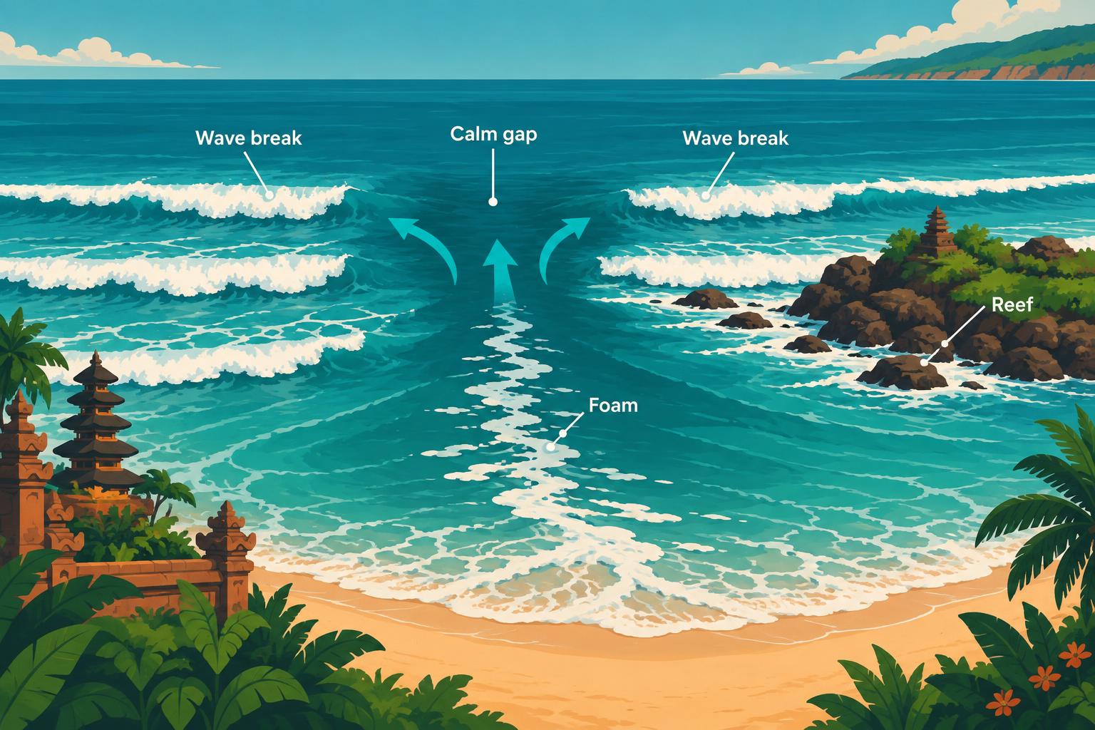
A calm-looking gap between waves may be a rip current
BMKG describes rip currents as strong flows away from shore that can sweep away even strong swimmers. Their behaviour depends on waves, tides and beach shape.
NOAA identifies these possible warning signs:
- A darker, apparently calmer gap between breaking waves.
- A patch of choppy or discoloured water.
- Foam, seaweed or debris moving seaward.
The smooth-looking gap can be especially misleading: fewer breaking waves do not necessarily mean safer water. These clues help you notice a possible hazard; they do not certify a beach as safe when absent.
If you suspect a rip, stay out and ask a lifeguard. Do not enter the water to test whether your interpretation is correct.
What Bali beach flags and lifeguard posts actually mean
Red-and-yellow flags identify a relatively safe swimming area
In local guidance dated January 29, 2026, from then-South Kuta tourist-rescue unit head I Wayan Somer, the space between paired red-and-yellow flags marks a relatively safe swimming area—not risk-free water.
The same guidance identifies areas between red flags as prohibited for water activities. Restrictions may reflect strong currents, rubbish or jellyfish, not only visibly large waves.
- Use the swimming area identified by the paired red-and-yellow flags when personnel permit entry.
- Do not enter an area marked as prohibited by red flags.
- Ask lifeguards about the conditions before entering.
If the flag arrangement is unclear, ask rather than guessing from its colour or copying another swimmer.
A Balawista post does not confirm that a lifeguard is on duty
Denpasar BPBD’s 2021–2026 strategic plan lists five Balawista posts: Matahari Terbit, Sanur, Le Mayeur, Segara Ayu and Serangan. That is an infrastructure record, not a current staffing roster.
A complete beach-by-beach schedule of patrol hours could not be verified as of November 8, 2026. Badung Lifeguard guidance reported May 25, 2026, gave supervision hours of 07:00–19:00 WITA, but this is not a verified November staffing roster or evidence of continuous coverage at every beach. Do not build a swimming plan around assumed coverage, including the assumption that an early visit will be supervised.
Look for personnel and speak to them. An unattended post, absent flags or a quiet beach does not amount to an all-clear.
How to check BMKG marine forecasts before swimming in Bali
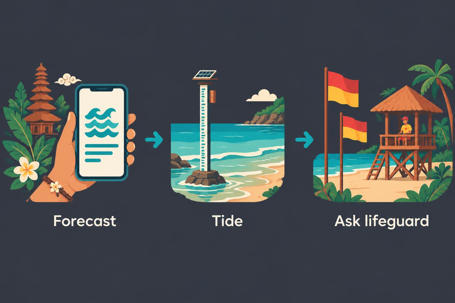
Read the coastal forecast, tide information and warning validity
BMKG Maritime provides separate menus for Perairan forecasts, Pelabuhan forecasts, Pasang Surut and high-wave warnings. Use the relevant coastal waters and check when the bulletin applies.
- Read the forecast for the waters relevant to your planned beach.
- Check high-wave warnings and their validity period.
- Consult tide information for your intended visit.
- Confirm the actual beach conditions with lifesaving personnel on arrival.
BMKG’s Benoa port forecast includes hourly tide information; the bulletin retrieved November 8, 2026, is valid from November 8 at 00:00 to November 11 at 00:00, 2026. Check the current bulletin and its validity before each visit. Port-area information is useful context—not certification of a particular lagoon or swimming entrance.
Regional wave warnings are not measurements inside a lagoon
As an example, the previously retrieved BMKG “Laut Bali” forecast was valid August 30–September 2, 2026. It must not be treated as swimming conditions for November 8, 2026.
Regional forecasts describe regional marine conditions, not wave heights measured inside Sanur’s lagoons. They should neither be copied directly onto a sheltered beach nor dismissed because the nearshore surface looks calm.
This example has expired with its bulletin. For your next swim, open the current forecast rather than relying on a saved screenshot, this article’s example or yesterday’s conditions.
A year-round resident’s routine for deciding when not to swim
Make the entry decision again on every visit
NOAA advises checking forecasts before leaving and speaking to the beach lifeguard. Rip currents can occur on calm, sunny days, so sunshine and familiarity are insufficient reasons to enter.
Use a simple decision routine:
- Before leaving: check BMKG forecasts, warnings and tides.
- At the beach: find the flags and personnel, then ask about your intended swim.
- Before entering: check usable depth, breaking waves and possible rip clues.
- Change the plan: stay out if swimming is prohibited, waves are dangerous or conditions remain uncertain.
For planning the journey rather than the water assessment, see the guide to living in Bali without a scooter. A swimming routine should leave room to turn back or choose another activity.
If caught in a rip, do not fight directly toward shore
NOAA’s rip-current survival guidance advises against swimming directly shoreward against the current. If able, swim parallel to shore to escape it, then angle back once free; if unable to escape, conserve energy and signal for help.
Strong swimming ability does not remove the hazard. Prevention—checking conditions and respecting restrictions—is more useful than assuming you could overpower a current.
Keep a non-sea alternative available. If that is a home pool, the guide to checking a Bali rental’s pool maintenance addresses its condition and upkeep; a pool is a different swimming environment, not something to assume is suitable without checking.
Frequently asked questions about swimming at Bali beaches
Which Bali beaches should regular swimmers investigate first?
Where is the safest beach to swim in Bali?
No beach can be named universally safest. Sanur’s reef-protected lagoons and the relatively calm waters described around Nusa Dua and Jimbaran are sensible starting points. Suitability still depends on the exact stretch, tide, waves, currents, flags and personnel present. Choose a locally advised swimming area on the day rather than relying on a permanent ranking.
Can you swim at Sanur Beach at low tide?
Sometimes the limiting issue is insufficient depth: official tourism guidance notes that Sanur’s reef areas can become very shallow at low tide. Check the actual lagoon and ask where swimming is appropriate. Do not automatically move farther offshore or into a reef opening to find deeper water. Reef shelter does not ensure usable swimming depth throughout the tide cycle.
What do flags and calm-looking water tell swimmers?
Is it safe to swim at Canggu or Berawa?
Do not assume west-coast beach access means suitable swimming. Badung police identified Berawa, alongside Petitenget, Batu Belig and Munggu, as strong-current, high-risk locations when installing warning flags. Check current restrictions and ask lifeguards about a permitted swimming area. Surfers, other swimmers or a calm-looking gap between waves are not evidence that entering is safe.
What do red-and-yellow flags mean in Bali?
Badung Lifeguard guidance says the space between paired red-and-yellow flags marks a relatively safe swimming area, not risk-free water. Areas between red flags are prohibited for water activities. Restrictions can relate to currents, rubbish or jellyfish as well as waves. Ask personnel before entering, especially if the arrangement or the intended swimming boundaries are unclear.
How should residents use forecasts and respond to a rip?
Does a calm BMKG forecast guarantee safe swimming?
No. BMKG marine and port forecasts provide weather, wave, current and tide context, but they do not certify a particular swimming beach. Regional forecasts also differ from conditions inside a sheltered lagoon. Check the relevant bulletin and validity period, then assess the beach and speak to lifeguards. A calm, sunny appearance does not rule out rip currents.
What should you do if a rip current carries you away?
Do not try to swim directly toward shore against the current. NOAA advises swimming parallel to shore if able, then angling back once free. If you cannot escape, conserve energy and signal for help. Rip currents can sweep away strong swimmers, so fitness is not a substitute for checking conditions, respecting flags and avoiding uncertain water.